Storm Babet latest: Met Office issues red weather warning, flooding in Ireland, UK braces for heavy wind & rain
and live on Freeview channel 276
The UK is bracing itself for heavy wind and rain as Storm Babet sweeps in from across the Atlantic. The Met Office has issued a rare red weather alert for parts of the country, warning of a “risk to life”.
Storm Babet, a complex area of low pressure which developed to the west of the Iberian Peninsula, was named by the Met Office on Monday morning. The second named storm of the season will last until Saturday, the forecaster said, and is expected to cause flooding, power cuts and travel disruption.
National World will be updating this live blog with the latest news as the extreme weather conditions continue to batter the nation.
Storm Babet latest as extreme weather conditions continue to batter the UK
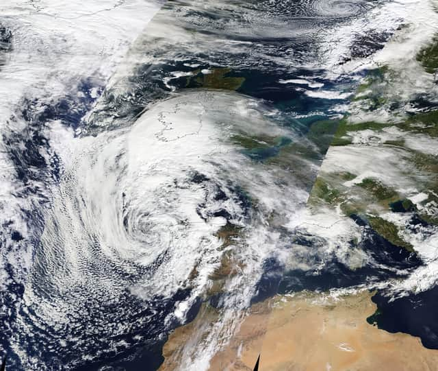
Satellite image shows Storm Babet heading for UK
A satellite image released yesterday shows the progress of Storm Babet as the UK braced for its arrival. The view from space showed the storm on Tuesday (17 October) as it made its way over northern France and towards the UK.
The incredible God's eye view was made possible by NASA's Earth Observing System Data and Information System (EOSDIS). The satellite imagery is available within three hours of observation - essentially showing the entire Earth as it looks "right now".

Met Office latest forecast
The Met Office has released a weather report showing Storm Babet arriving in the south bringing with it heavy downpours. The forecast, presented by Aidan McGivern, confirm conditions are currently drier in the north.
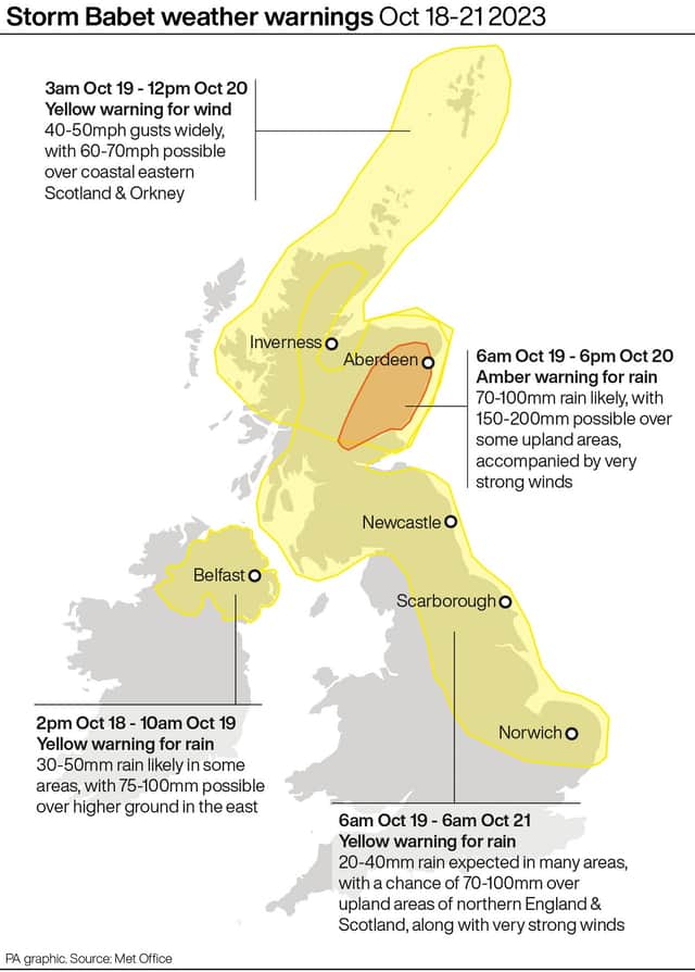
Met Office weather warnings issued across UK
A rare red weather warning stating there is a “risk to life” has been issued for parts of Scotland as Storm Babet is expected to batter the UK on Thursday. The UK is bracing for heavy wind and rain from the storm, which is currently hitting Ireland after sweeping in from the Atlantic.
The red warning states there is “danger to life from fast flowing or deep floodwater” in Aberdeenshire and Angus, with extensive flooding and road closures also expected. This is the first red warning for rain issued in the UK since Storm Dennis in February 2020.
Yellow severe weather warnings have been issued across the week from Thursday until Saturday for a vast swathe of the UK, covering already-saturated parts of Scotland, Northern Ireland, and northern and eastern England.
Met Office chief meteorologist, Jason Kelly, said: “Confidence has increased in the chances of considerable impacts from rainfall in parts of the east of Scotland from Storm Babet, which has resulted in the escalation to the red warning. One hundred to 150mm of rain is expected to fall quite widely within the warning period, with some locations likely to see 200-250mm, which is expected to cause considerable impacts, with flooding likely.
“Storm Babet will track gradually northwards in the coming days, and although the most significant impacts are expected within the red and amber warning areas, there will still be wider impacts for much of the UK from this wind and rain.”
Storm Babet weather warnings
The Met Office has issued weather warnings across the UK from today (October 18) until Saturday (October 21).
Do not travel warning: People urged to stay off roads in worst affected areas
David Morgan, flood duty manager for the Scottish Environment Protection Agency (Sepa), has urged people in affected areas to check for flood updates in the coming days. He said: “Storm Babet will bring heavy rain and high winds across Scotland from Wednesday evening, starting in the south-west before moving across to the north-east through Thursday and into the weekend.”
He continued: “Impacts from surface water and rivers are likely, and with catchments saturated from recent heavy rain and flooding, we’re urging people to be prepared for potential flooding. There is also concern that surface-water flooding may be exacerbated by debris blocking drainage, culverts, etc. as a result of the high winds.”
Transport Scotland has advised the public to avoid travel in red warning areas and to expect a high risk of disruption in the amber areas. Operator manager Stein Connelly said: “People need to plan ahead and be prepared. Avoid travel unless essential.
“If you do need to travel, check before you travel as your journey is likely to be affected by these latest severe weather warnings. For those in Angus and South Aberdeenshire, the advice is clear – do not travel during the period the red warning is in effect. The rain is expected to present some really challenging conditions.